Europe is a sui generis continent: even being the least of them, it is the cradle of the most influential civilisation ever, the Western Civilisation, which, having spread to every corner of the Earth, became the Global Civilisation, so that today the Western — i.e. European — lifestyle is everywhere, even among the most resistant people to foreign influence. Moreover, Europe has an extreme ethnic and cultural homogeneity: an exclusively white native population (Europeans from other ethnic groups are the result of recent immigration), few linguistic families originating — with very few exceptions — from a single ancestral language called Indo-European (which appeared in the Caucasus around the sixth millennium BC), and, above all, a unique cultural legacy resulting from crossbreeding the Graeco-Roman civilisation with Christianity.
Geographically, Europe is a landmass extending horizontally from east to west, with islands and/or peninsulas projecting to the north and south. This landmass is confined between two seas, the North Sea to the north and the Mediterranean to the south; it is narrower to the west and widens towards the east. The western part of the continent is occupied in its centre-south by the Italic peoples, also called Latin, Neo-Latin or Romanic, while the centre-north is populated by the Germanic (or Teutonic, or Saxonic) peoples. Eastern Europe is dominated by Slavs and some other ethnic groups (Greeks, Finno-Ugrians, Albanians, etc.) who do not take part in the supersynchronistic phenomenon. Observe the following map of Europe (Figure 1):
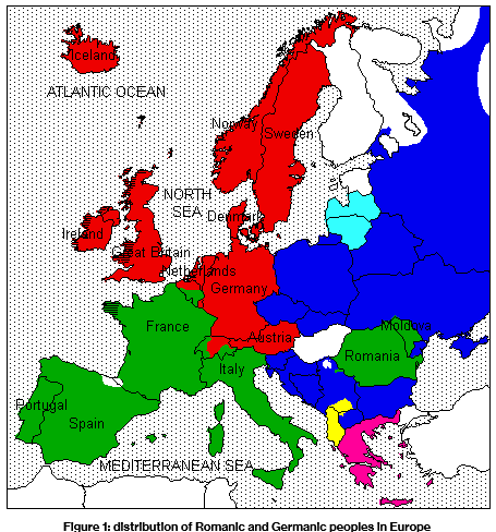
In Figure 1, the peoples of Romance languages occupy the green area and those of Germanic languages, the red area. (Note that some states share more than one language, so they are not part of either group, but work as satellite states in the system; further, we will see that they also play a role in the establishment of symmetries.) The dark blue represents the Slavs, the clear blue the Baltic peoples, the rose Greeks, yellow Albanians, and the white areas are populated by peoples of non-Indo-European languages such as Hungarians, Finns and Turks.
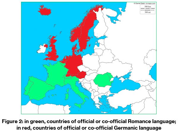
Focusing on the Romanic and Germanic peoples only, we observe that the two families form inverted arcs (Figure 2).
In Figure 1, the peoples of Romance languages occupy the green area and those of Germanic languages, the red area. (Note that some states share more than one language, so they are not part of either group, but work as satellite states in the system; further, we will see that they also play a role in the establishment of symmetries.) The dark blue represents the Slavs, the clear blue the Baltic peoples, the rose Greeks, yellow Albanians, and the white areas are populated by peoples of non-Indo-European languages such as Hungarians, Finns and Turks.
Focusing on the Romanic and Germanic peoples only, we observe that the two families form inverted arcs (Figure 2).
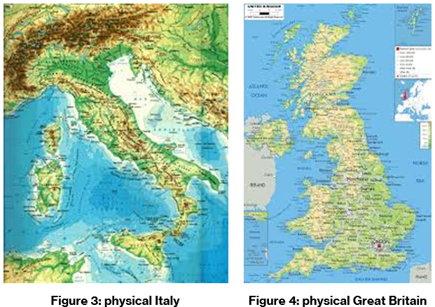
Both Great Britain and Italy are landmasses distributed vertically and have as their backbone a chain of mountains that runs from north to south. In Italy, this chain is the Apennine Mountains; in Great Britain, it is the Pennine Mountains. As Britain is an island, British culture is often called “insular”; similarly, the culture originating from the Italian Peninsula is called “peninsular”. In addition, there is a region in Italy called Umbria; in England, there is Northumbria (Northumberland), literally North Umbria. The territories of both Italy and Great Britain are wider near the continent and narrower as they advance towards the sea. Finally, Italy has a province called Trento and England, a river called Trent.
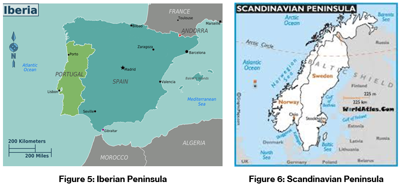
Looking now at the Iberian and Scandinavian peninsulas (Figures 5 and 6), we see two geographic masses pointing westward and divided into two countries, one of which (Portugal, in the Iberian case; Norway, in the Scandinavian) occupies a narrow strip of land from north to south, on the western edge of the peninsula, facing the Atlantic. Most of both peninsulas is occupied by two other countries: Spain and Sweden, respectively. Both peninsulas are home to peoples known for their past of great navigators: the Scandinavian Vikings explored the extreme north of America (Greenland and Canada) between the 9th and 11th centuries, while the Portuguese and Spaniards conquered America in the 15th and 16th centuries (in a certain way we can say that both the Iberians as the Scandinavians ‘discovered’ America). As a curiosity, the Norwegians are major producers of cod, called by them “white gold”, and the Portuguese, large consumers. Incidentally, some historical sources say that the Portuguese fished it in the waters of present-day Canada since the 14th century and were also their introducers in gastronomy (today, cod is the Portuguese national dish). However, other sources reveal that cod was already caught and consumed by Norwegian and Icelandic Vikings since the 9th century. And that the Portuguese were hired by the Norwegians in the Middle Ages as sailors and cod fishermen.
Finally, both Scandinavia and Iberia have a region called Lapland. Scandinavian Lapland covers a large part of Sweden, Norway, Finland and Russia, while the so-called Spanish Lapland or South Lapland is in Spain; they are the two regions with the lowest demographic density in the European Union (see www.elhueco.org/northern-lapland-and-spanish-lapland-will-meet-at-el-huecos-meeting-in-may). And the geographic name Gotland ‘land of the Goths’ exists in both Scandinavia and Iberia: in Sweden there is the island Gotland, and in Iberia there is Catalonia, whose name, according to most etymologists, comes from Gotland.
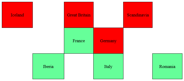
The nucleus of this large system consisting of both families (which, by the way, constitute the core of Western Civilisation, since the peoples of Eastern Europe had little or no participation in the historical development of this civilisation) are the four central countries on the map of Figure 1: France, Great Britain (England, Scotland, Wales and Ireland also once), Italy and Germany (which has historically included Austria). Around these four nations until recently did the whole history of the West revolve: there happened the great historical facts, major political, economic, cultural and religious movements (discussed below), as well as the great scientific discoveries; today these four nations are at the centre of the European Union[1] and are the four political and commercial powers of Europe (they are the only four European nations to join the so-called G7, the group of the richest and most powerful nations on the planet).
It is necessary here to make a reservation, which will be important for understanding the whole theory that underlies supersynchronicity: comparing the two arcs formed by the Romanic and Germanic territories, one can have a first impression that the mirror nation of France is Germany, and of Italy is Britain. This is in part true geographically, but in other respects that we will study (historical, cultural, linguistic and even elsewhere in geography), what we have are two types of analogy that combine in a complex mathematical pattern: one vertical and one diagonal (this point of the theory is explained in The laws of supersynchronicity), so that the vertical (e.g. between France and England) is the main or predominant, and the diagonal (between France and Germany) secondary and weaker. However, it is the game of both analogies which makes supersynchronicity an interesting and little obvious phenomenon: if there were relations of a single type, we would not have symmetry, but identity.
Observe now Figure 7.
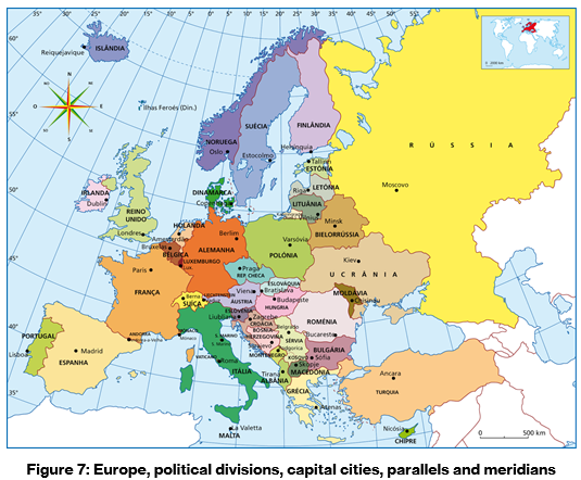
The group formed by France, Britain, Ireland, Belgium and Iberia is located approximately between the 5ºE and 10ºW meridians, while the group of Italy, Switzerland, Austria, Germany, Netherlands and Scandinavia is located approximately between the 5ºE and 20ºE meridians, thus occupying geographical ranges of equal width (approximately 15 degrees). Farther west (15ºW to 25ºW meridians) is Iceland, and much more to the east (20º to 30ºE meridians) are Romania and Moldova.
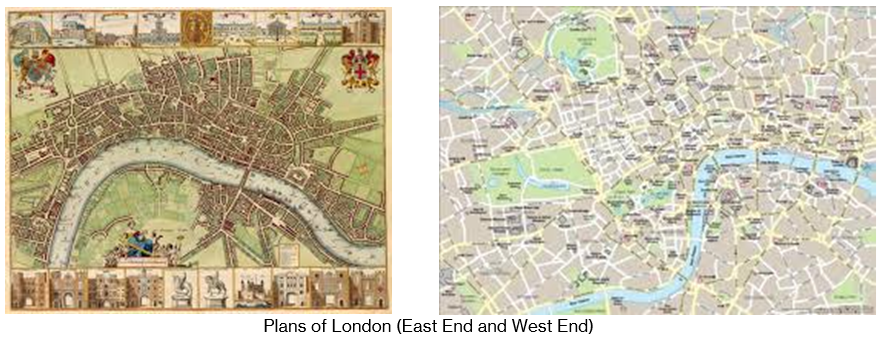
The capitals Paris and London, as well as Rome and Berlin, are approximately at the same longitudes. In fact, there are numerous topographical and touristic similarities between Paris and London, as well as between Rome and Berlin, which I will speak of in specific articles.
The 5ºW meridian limits the north-western edge of France and the south-western edge of England. These two ends are called “end of the land” (capes Finistère in France and Land’s End in England).
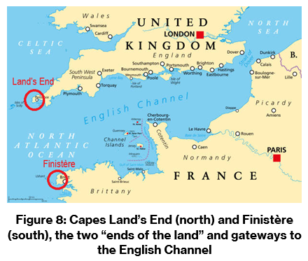
The region where the Finistère is located is called Brittany, or Little Britain, and there inhabit the Bretons, people of Celtic origin who speak the Breton language. In Brittany there is a region called Cornouaille (from the same origin as Cornwall).
Across the English Channel, in Britain (i.e. Great Britain), the Land’s End is in the region also called Cornwall, inhabited by a Celtic people of Cornish language. At the other end, the cities of Dover in England and Calais in France, separate the English Channel from the North Sea. Indeed, France, Britain, Iberia and Scandinavia are bathed by both the Atlantic Ocean and their respective internal seas (Mediterranean and North). In turn, Italy and Germany are bathed by these seas and also the Adriatic (in the case of Italy) and the Baltic (in the German case). The Baltic also bathes Sweden, as well as the Bay of Biscay bathes Spain.
A curiosity: in Antiquity, Gaul, that is, the region of present-day France, was inhabited by the Gauls (Gaulois, in French), and the British Isles were inhabited by the Britons. Today, in northwestern France there is Brittany, inhabited by the Bretons, and in southwestern Britain is Wales, inhabited by the Welsh (in French, Gallois). |
The main rivers of France and England, respectively the River Seine and the River Thames, cut the capitals Paris and London in the east-west direction. The main rivers of Italy and Germany, that is to say, the Po and the Rhine, pass far from the capitals Rome and Berlin. These are bathed by two small rivers, respectively the Tiber (Tevere) and the Spree. The valley of the River Po and that of the Rhine are the most industrialised regions of their respective countries. In addition, the valley of the River Po is also known as Padania (from the Latin name of the river, Padus); in contrast, the most important region of Germany cut by the Rhine, the Rhineland, is called Renania in the Romance languages.
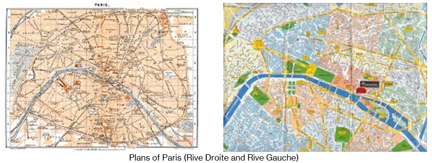
The centre of Paris is known as the Cité (fortified city), so much so that the Seine island located downtown is called Île de la Cité. Similarly, central London is known as City.
The River Seine divides Paris into two areas, the Rive Droite (right bank, north of the river) and the Rive Gauche (left bank, south), just as the River Thames separates London into the North Bank and the South Bank. Both Parisian Rive Droite and London’s South Bank are predominantly areas of entertainment, bohemia, theatres, restaurants and the housing and workplace of artists in general.
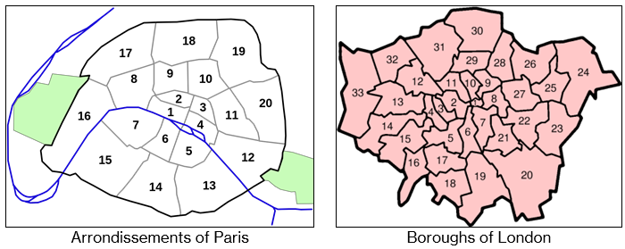
It is also worth mentioning that Paris and London were for a long time the two largest European metropolises and are home to some of the most important international organisations.
Also noteworthy are the geographical and historical similarities between Venice and Amsterdam, which we will speak of in more detail in Nations and their “mirrors”, and between Rome and Berlin, especially with regard to the enclaves that exist or existed within them. It is the Vatican State, established in 1929, which is an independent territory belonging to the Holy See within the city of Rome and surrounded by a great wall, the Vatican Wall, as well as the city of East Berlin, created in 1949 and extinguished in 1990, enclave and capital of the old East Germany inside the city of Berlin and separated of West Berlin by the famous and now almost completely demolished Berlin Wall.
Note the years of creation of these enclaves: Vatican, 1929; East Berlin, 1949.
__________
[1] The United Kingdom left the European Union in 2020.